Google Maps is getting over 100 upgrades — and these are the 5 biggest
Google Maps is about get a whole lot better, with some help from AI
Google Maps just got another huge update, bringing with it lots of fancy features to help you get around. In total, the update delivers more than 100 improvements, many of which are powered by AI and machine learning.
Features coming to Google Maps include indoor live view, more eco-friendly route-planning, pollution maps and more. Here are the biggest changes coming to Google Maps this year, and what the update means for you.
- How to use Google Maps: Essential tips and tricks
- These are the best Google Assistant commands you can try right now
- Just in: New Google Pixel Buds leak teases a cheaper pair of wireless earbuds
Indoor Live View
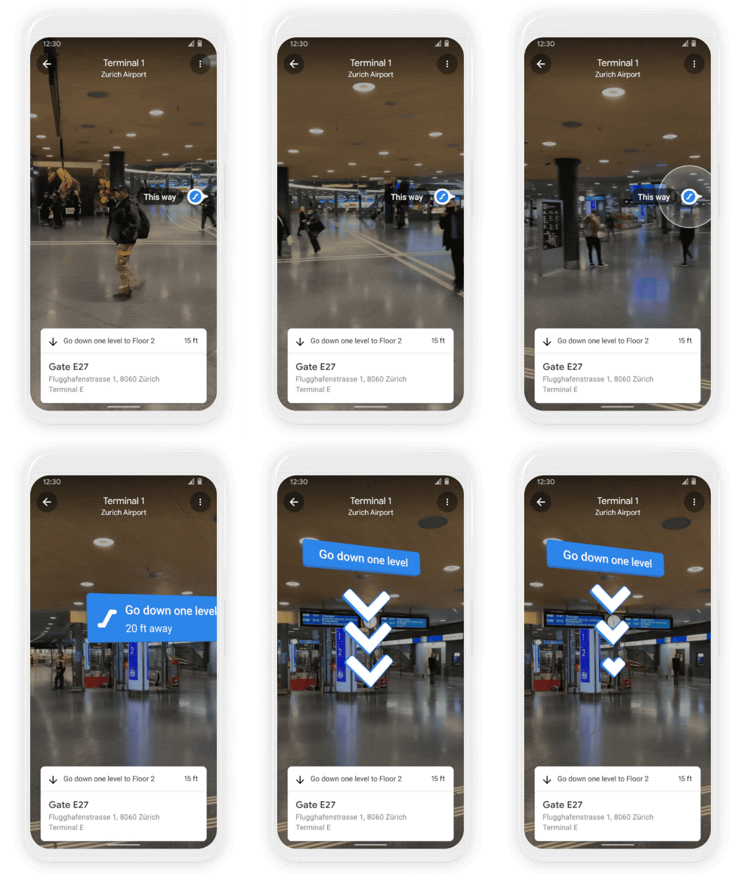
One of the more interesting features to hit Google Maps back in 2019 was Live View, which lets you use AR to see your directions in the context of the real world. The update will bring Live View to indoor locations, which is good news as they're often among the most awkward places to navigate.
The principle is the same, but recent advancements mean Google Maps can better understand altitude and the placement of things within a building; the result is that AR-powered indoor navigation is now fit for purpose.
Indoor Live View is already available on Android and iOS, with AR directions available for a number of malls in Chicago, Long Island, Los Angeles, Newark, San Francisco, San Jose, and Seattle. It will also be rolling out to malls, airports, and other transit stations in Tokyo and Zurich over the coming months. Other cities will be part of the rollout eventually, but Google hasn’t specified when.
Integrated weather and air quality
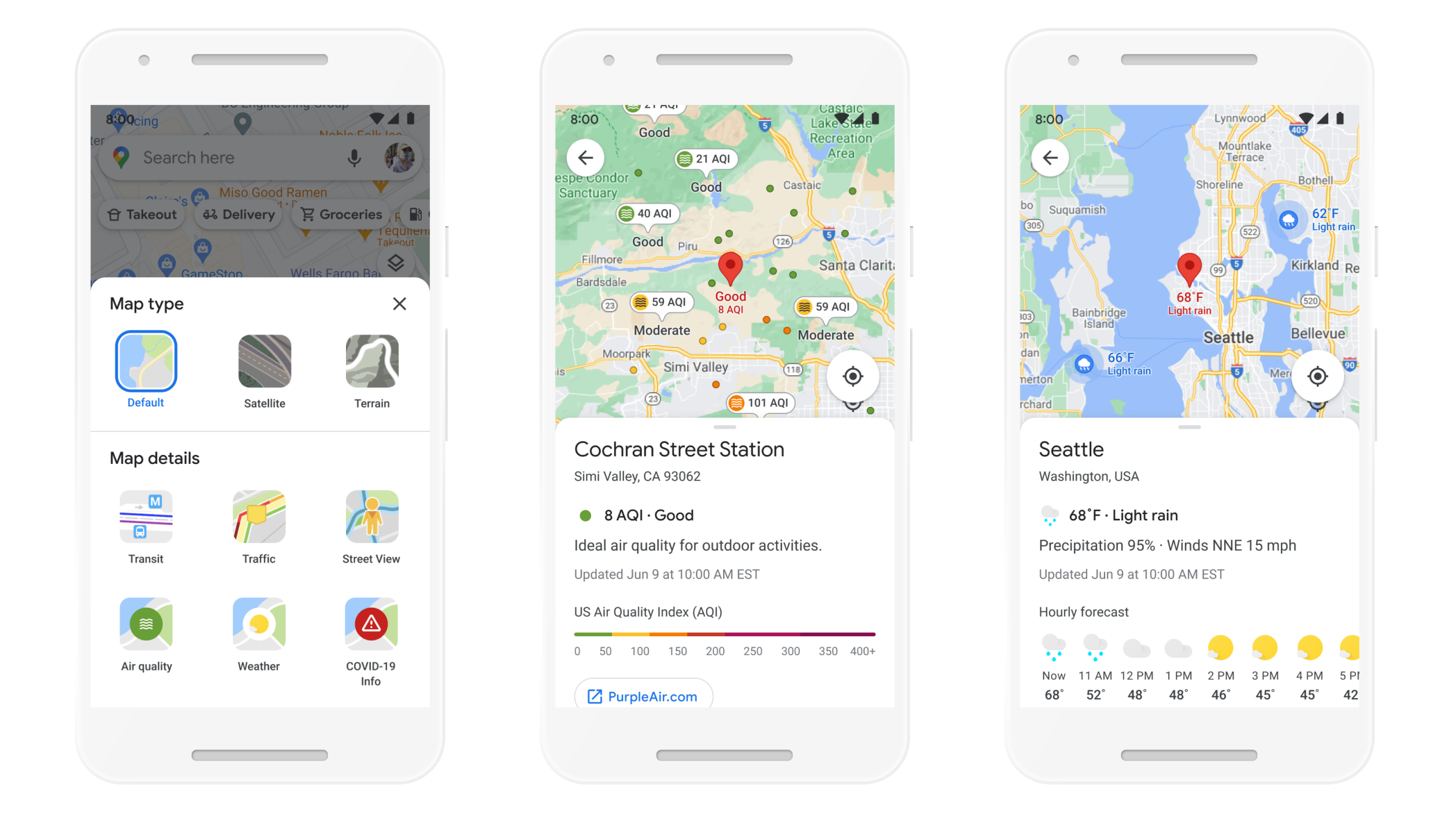
Your phone already has a weather app preinstalled, but now Google is rolling those features into Google Maps.
With the Weather layer, you’ll be able to see current and forecasted weather in an area, ensuring you’re always prepared for whatever the skies may throw at you. Another new layer, meanwhile, will tell you what the quality of the local air is like.
Sign up to get the BEST of Tom's Guide direct to your inbox.
Get instant access to breaking news, the hottest reviews, great deals and helpful tips.
Both layers will rely on data from a number of third parties, including The Weather Company, AirNow.gov, and the Central Pollution Board. The weather layer will be available worldwide, though the air quality layer will initially be restricted to Australia, India, and the U.S.
Weather and air pollution will be available on Android and iOS, with a rollout set to occur in “the coming months.”
Eco-friendly driving options
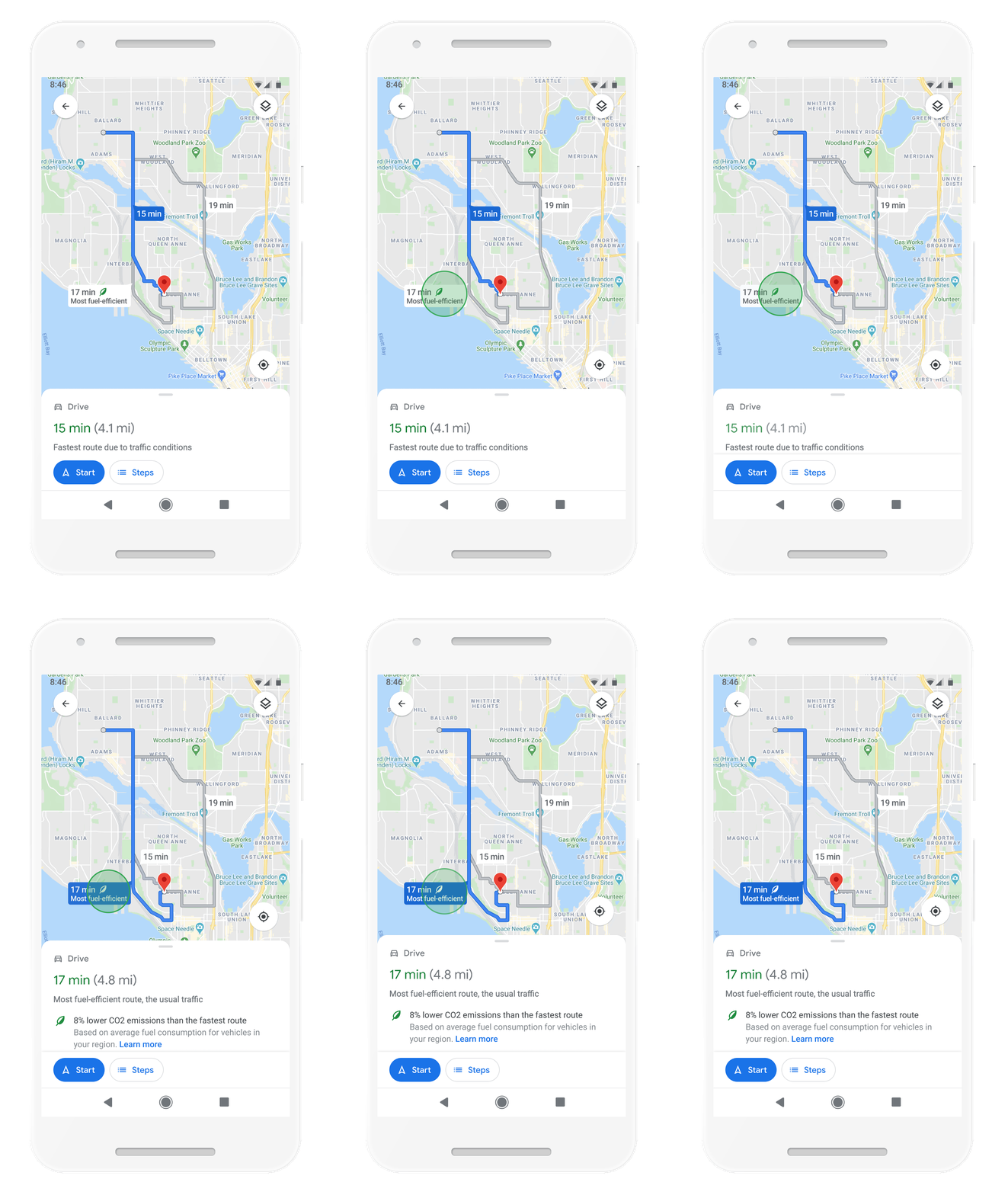
Driving is far from the most environmentally conscious way to get around, unless you're using one of the best electric cars, but Google Maps will now help you make your trips as green as possible.
Part of that involves a new routing model that optimizes your journey for fuel consumption, built in conjunction with the US Department of Energy’s National Renewable Energy Lab.
Once this new feature arrives, Google Maps will automatically default to routes that have the lowest carbon footprint. This will have the added bonus of saving you money, because more efficient fuel consumption means you won’t need to fill up with gas quite as often.
The clincher here is that these newly optimized routes will have roughly the same ETA as the fastest route available, so you won't be delayed by taking a slightly more efficient trip. Of course if speed is everything, then you'll still be able to tell Google that you always want the fastest route, no matter what. The new route optimization feature will launch on Android and iOS in the U.S. later this year, with a global rollout to follow.
In another update for drivers, Google Maps will also warn you if you're heading into a low emission zone. That way, you can avoid areas where your car isn’t allowed, saving you hassle and charges that stem from not having a zero- or low-emission vehicle. That arrives in June in Germany, Netherlands, France, Spain, and the U.K. More relevant countries will follow later.
A new alternative transit interface
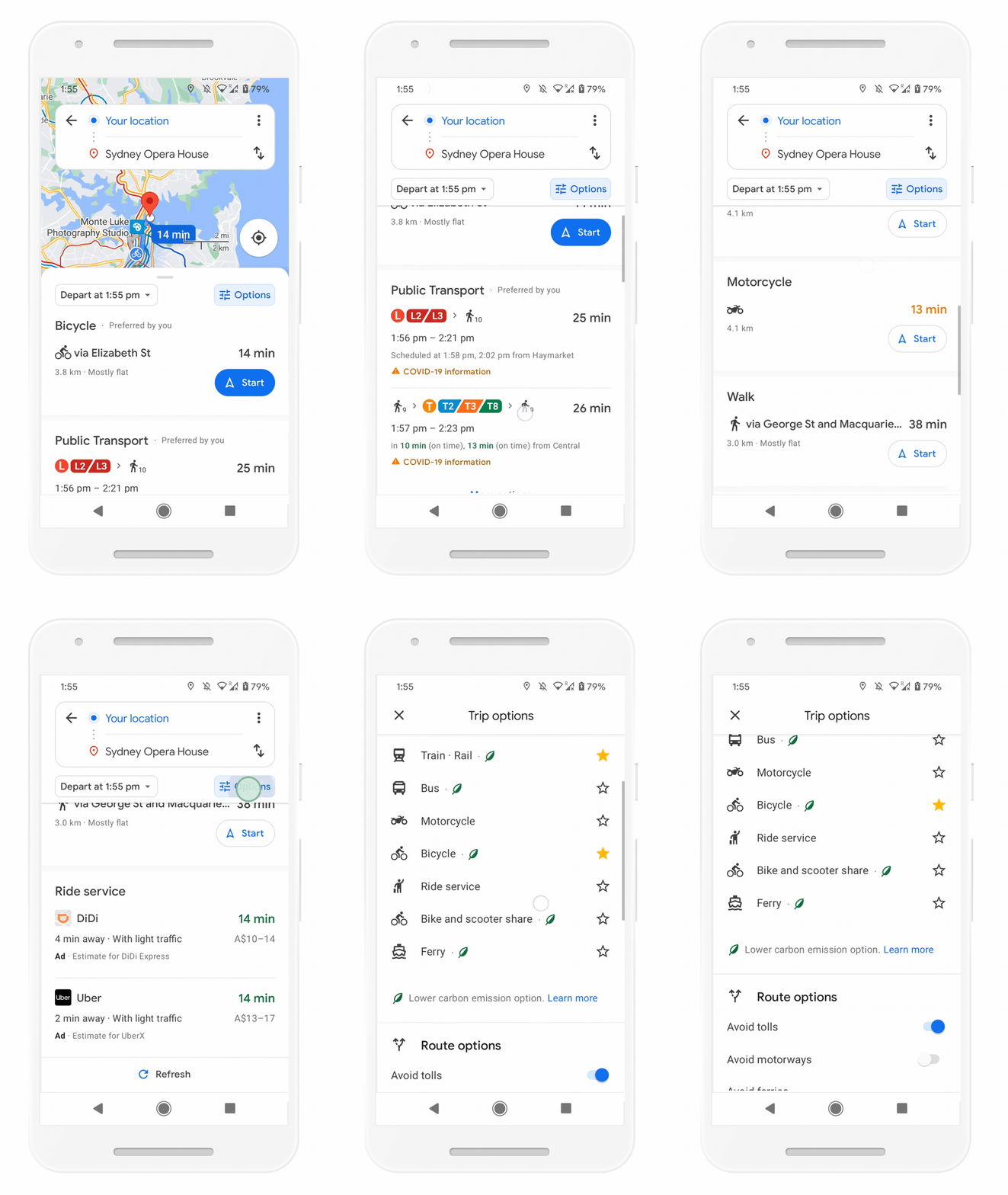
When it comes to sustainability, nothing beats travelling by alternative transit options, whether that’s public transportation, walking or cycling. To simplify the journey-planning process, Google is launching a new directions interface that makes it easier to switch between different routes and transit options.
What’s more, Google Maps will employ machine learning to remember how you prefer to get around, prioritizing the options you’re more likely to use. Plus, switching between different ways of getting around won’t involve toggling different tabs on a screen, as is currently the case.
Google Maps also takes locational context into account, and will push transit systems that are popular wherever you are. So, if you’re in a city like New York or London, you’ll see underground Subway routes ranking higher on your list of ways to get around; presumably the same will be true if there are ebike or scooter rental spots nearby.
This feature will roll out in the “coming months” on Android and iOS devices.
Curbside grocery pickup support
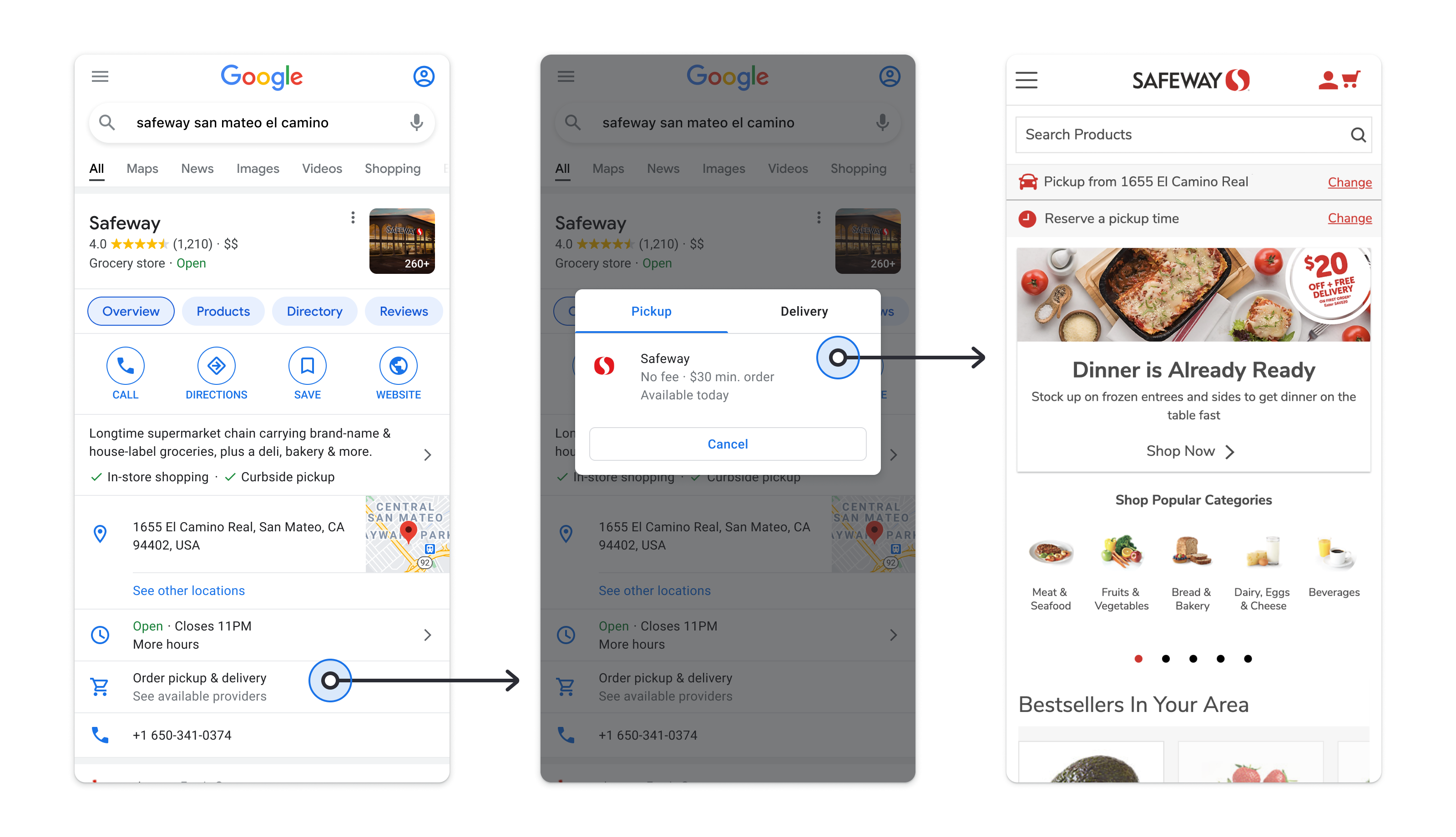
Despite the incredible work that’s gone into vaccinating people, COVID is still around. During the pandemic, grocery stores and other retailers have been making shopping that bit safer by offering curbside pickup — and that’s now something that Google Maps is also going to help with.
An update to Google Maps and Search will add relevant information to Business Profiles, so you can see which businesses offer pickup from the curb plus details about delivery windows, minimum orders, and what other fees you may need to pay.
This extra information will first come to Instacart and Albertsons Cos profiles in U.S. search results, but will be expanding to Maps and other businesses in the near future.
Google Maps has also teamed with supermarket Fred Meyer, and will be running a pilot scheme in Portland, Oregon, to make grocery pickup even easier.
Once you place an order for pickup, you’ll be able to add that location to Maps; the app will then tell you when it’s time to leave, and will inform the store of your ETA, so that your order is ready as soon as you arrive.
- More: Google Maps vs Waze: Which navigation app is better for you?

Tom is the Tom's Guide's UK Phones Editor, tackling the latest smartphone news and vocally expressing his opinions about upcoming features or changes. It's long way from his days as editor of Gizmodo UK, when pretty much everything was on the table. He’s usually found trying to squeeze another giant Lego set onto the shelf, draining very large cups of coffee, or complaining about how terrible his Smart TV is.
